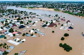
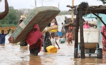
The Federal Government has disclosed that 226 local government areas across 33 states and the Federal Capital Territory fall within high flood risk zones in the 2026 flood outlook.
The Minister of Water Resources and Sanitation, Joseph Utsev, made the announcement on Wednesday during the public presentation of the 2026 Annual Flood Outlook by the Nigeria Hydrological Services Agency held at the State Banquet Hall of the Aso Villa in Abuja.
According to the outlook, 14,118 communities in 266 local government areas across 33 states and the FCT are classified as high flood risk areas.
The affected states include Abia, Adamawa, Anambra, Bauchi, Bayelsa, Benue, Borno, Cross River, Delta, Ebonyi, Edo, Enugu, Gombe, Imo, Jigawa, Kaduna, Kano, Kebbi, Kogi, Kwara, Lagos, Nasarawa, Niger, Ogun, Ondo, Osun, Oyo, Plateau, Rivers, Sokoto, Taraba, Yobe, Zamfara, and the FCT.
The report further indicated that 405 local government areas in 35 states fall within the moderate flood risk category, with only Ekiti State excluded from this classification.
In addition, minimal flood risks are expected in 923 communities across 77 local government areas in 24 states, including Adamawa, Anambra, Bayelsa, Benue, Borno, Cross River, Delta, Edo, Jigawa, Kaduna, Kano, Kebbi, Kogi, Nasarawa, Niger, Ogun, Ondo, Osun, Oyo, Sokoto, Taraba, and Zamfara.
The minister explained that this year’s outlook introduces a community-based flood forecasting system designed to provide localized warnings and improve early response efforts.
He noted that the new approach will help authorities and residents better prepare for potential flooding by tailoring forecasts to specific communities for quicker intervention.
The government has urged states and local authorities to intensify preparedness measures, especially in identified high-risk areas, as part of efforts to reduce the impact of seasonal flooding across the country.


